
SingularXYZ SingularXYZ-E1(1+1)
SingularXYZ E1 RTK GNSS Survey Equipment User Manual
Model: SingularXYZ-E1(1+1)
1. Einleitung
The SingularXYZ E1 RTK GNSS Survey Equipment is a high-precision positioning system designed for land surveying, navigation, and various geospatial applications. This manual provides detailed instructions for setting up, operating, and maintaining your E1 system to ensure optimal performance and longevity.
1.1 Was ist in der Box?
The E1 RTK GNSS Survey Equipment package includes the following components:
- E1 GNSS Receiver (x2)
- Transport Case (x2)
- USB-Type C Cable (x2)
- Super Charger (x2)
- Kurzanleitung (x1)
- Quick Start Card (x1)
- SC200 Data Collector (x1)
- USB cable (for SC200) (x1)
- Super Charger (for SC200) (x1)
- Halterung (x1)
- SingularPad Software (x1)
- Whip Antenna (x2)
- Tape Measure (x1)
- 20 cm extension rod plugged on tribrach (x1)
- Tribrach (x1)

Abbildung 1.1: Überview of the E1 RTK GNSS Survey Equipment and its main components.

Figure 1.2: Detailed breakdown of the E1 Base and Rover components, including adapters, software, and data collector.
2. Produktmerkmale
The E1 RTK GNSS Survey Equipment is engineered with advanced features to provide reliable and accurate surveying capabilities:
- Hohe Präzision: Achieves centimeter-level precision measurement with low power consumption.
- IMU Integration: Supports tilt measurements up to 60° with quick initialization (5 seconds).
- Erweiterte Reichweite: Radio range between rover and base can reach up to 5 kilometers (3.1 miles).
- Full-Constellation Tracking: Supports GPS, GLONASS, Galileo, BDS, QZSS, IRNSS, SBAS for robust signal acquisition in challenging environments.
- Vielseitige Konnektivität: Features NFC (Touch connection), Bluetooth, USB Type-C, WiFi, TNC Connector, and RS232 Serial Port.
- Lange Ausdauer: 6700mAh battery provides over 20 hours of continuous operation.
- Langlebiges Design: Schutzart IP68 für wasser- und staubdichten Schutz.

Figure 2.1: Key features of the E1 receiver, including NFC one-touch connection, compact size, easy data download via Web UI, and fast charging capabilities.

Abbildung 2.2: Ausführlich view of the E1 receiver's front panel indicators (Satellite Tracking, Static & Network, Correction Data, Power) and various interfaces (NFC, Type-C, TNC, RS232).

Figure 2.3: Information on the SC200 Data Collector, highlighting its Android OS, processor, RAM, storage, sunlight-readable screen, and integrated connectivity.

Figure 2.4: The E1's Web UI allows for easy static data download, firmware upgrades, and configuration via WiFi.

Figure 2.5: A comparative overview of the E1's specifications against typical industry alternatives, highlighting its advantages in channels, trans-range, IMU, battery life, and material protection.
3. Einrichtung
3.1 Geräteanschluss
Connecting your GNSS device to the SingularPad software is crucial for operation. Follow these steps:
- Turn on your GNSS device.
- On the data collector, navigate to Device >> Communication.
- Select the appropriate device manufacturer and type (e.g., SingularXYZ >> RTK >> Bluetooth for SingularXYZ RTK Receivers, or Other >> RTK(NMEA0183) >> Bluetooth for other brands, or Other >> Internal GPS for SingularXYZ GNSS Tablets).
- Suchen nach your device's serial number (SN) and connect.
- After connection, you can view current device information by going to Device >> Device Information.
Video 3.1: Singular Software Tutorial - Device Connection. This video demonstrates the process of connecting your GNSS device to the SingularPad software.
3.2 Arbeitsmodi
The E1 system supports two primary working modes:
- Base + Rover (Radio/UHF): This mode is compatible with base stations from other brands and is not subject to network and regional restrictions.
- Rover + CORS (NTRIP): This mode requires a CORS account (purchased from your local CORS provider) and a network signal.

Figure 3.1: Illustration of the two main working modes for the E1 RTK GNSS system: Base + Rover using radio/UHF and Rover + CORS using NTRIP.
4. Bedienungsanleitung
4.1 SingularPad Software Usage
The SingularPad software provides a comprehensive interface for managing projects, collecting data, and performing various surveying tasks. It offers features like project management, coordinate system settings, point database, and various survey methods.

Figure 4.1: The SingularPad software interface, designed for ease of use with functions like one-click fixation, road stakeout, and power line survey.

Figure 4.2: A flowchart illustrating the quick start workflow for E1 surveying, from creating a new project to exporting data.
4.2 Tilt Surveying
The E1 system features IMU technology allowing for tilt surveying up to 60 degrees with high accuracy and fast initialization.

Figure 4.3: The E1's capability for tilt surveying, showing measurements at various angles up to 60 degrees with 1cm accuracy and 5-second fast initialization.

Figure 4.4: The E1 system's ability to measure with up to 60° tilt, providing ±2.5cm accuracy for tilt surveying.
4.3 Working with E1 Rover + Base
To configure the E1 system for Rover + Base operation:
- Ensure you have two E1 GNSS receivers, designating one as the base and the other as the rover.
- Connect them separately to your PDA device via Bluetooth.
- Place both your E1 base and rover in an open view des Himmels.
- Connect the whip antenna to both E1 base and rover.
Einrichten der Basis:
- Connect E1 base to your PDA, go to Device >> Base.
- Für Base Startup Mode, you can input known point coordinates to setup, or select Einziger Punkt mode for automatic setup.
- Satz Datenverbindung as Internal Radio, and customize radio channels, frequency, and protocol according to your needs.
- Save settings and Start Base. The status bar will become Base.
Setting up the Rover:
- Connect E1 base to your PDA and connect to the rover in the software.
- Gehe zu Device >> Rover, set Data Link as Internal Radio.
- Match and set the same protocol and frequency as the base setting.
- Klicken Sammlung to save settings and click Anwenden.
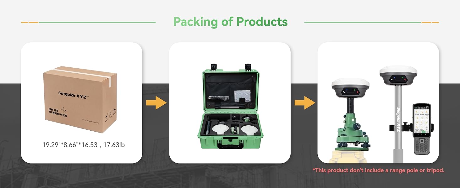
Figure 4.5: Step-by-step guide for setting up the E1 as a Rover and Base, including software interface screenshots for configuration.
4.4 Working with CORS/RTK Correction Service
To use the E1 system with a CORS/RTK Correction Service:
- Purchase a CORS/RTK Correction Service account in your local area.
- Ensure your PDA device (phone/tablet/data collector) can access network and support Bluetooth connection.
- Place your E1 GNSS receiver in an open view des Himmels.
Schritte:
- Open SingularPad software.
- Click "Communication" and connect to your E1 receiver's SN via Bluetooth.
- Click "Rover" >> Set Data Link as Phone Internet, then go to Verbindungsmodus and fill in your CORS/RTK Correction Service account details.
- Klicken Erhalten to obtain MountPoint list and select appropriate one. Click Start Und Anwenden.
Note: Find the appropriate mount point via the website of your local CORS/RTK Correction Service provider. Ensure the baseline is within 50km. Be noted that the long baseline will affect the RTK performance and measuring accuracy.
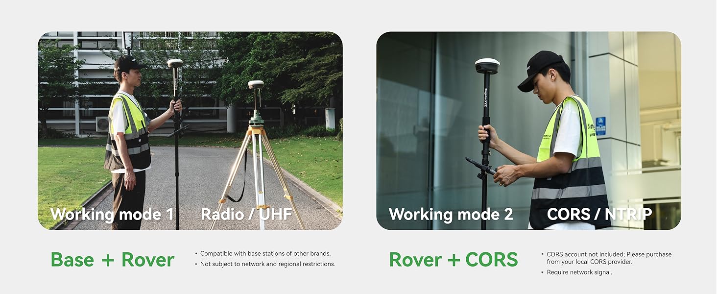
Figure 4.6: Guide for configuring the E1 system to work with a CORS/RTK Correction Service, including software interface screenshots for connection and settings.
5. Wartung
5.1 Akku und Aufladen
The E1 RTK GNSS receiver is equipped with a 6700mAh battery, providing over 20 hours of continuous operation. It supports fast charging via its Type-C port.
- Ladezeit: Eine vollständige Aufladung dauert ungefähr 3.5–4 Stunden.
- Betriebszeit: Over 20 hours on a single charge.

Figure 5.1: Information on the E1's battery performance, indicating 3.5-4 hours for fast charging and over 20 hours of continuous working time.
5.2 Reinigung und Lagerung
To maintain the device's performance and extend its lifespan:
- Reinigen Sie das Gerät regelmäßig mit einem weichen, damp Tuch. Vermeiden Sie aggressive Chemikalien.
- Stellen Sie sicher, dass alle Anschlüsse frei von Staub und Schmutz sind.
- Store the equipment in its transport case in a dry, cool place when not in use.
- The E1 is IP68 waterproof and dustproof, but avoid prolonged submersion or exposure to extreme conditions.
6. Fehlerbehebung
This section addresses common issues you might encounter with your E1 RTK GNSS Survey Equipment. For more complex problems, please refer to the support section.
6.1 Häufige Probleme und Lösungen
| Problem | Mögliche Ursache | Lösung |
|---|---|---|
| Gerät verbindet sich nicht über Bluetooth | Bluetooth is off; device not discoverable; incorrect device selected. | Ensure Bluetooth is enabled on both devices. Make sure the E1 is in pairing mode. Select the correct device SN from the list. |
| No RTK fixed solution | Poor satellite visibility; incorrect base/rover setup; no correction data. | Begeben Sie sich in einen offenen Bereich mit klarem Himmel view. Verify base and rover settings (frequency, protocol). Check CORS connection or radio link. |
| Kurze Akkulaufzeit | Battery not fully charged; old battery; extreme temperatures. | Ensure full charge before use. Consider battery replacement if old. Operate within recommended temperature ranges. |
7. Spezifikationen
Detailed technical specifications for the SingularXYZ E1 RTK GNSS Survey Equipment:
| Spezifikation | Wert |
|---|---|
| Artikelgewicht | 18.3 Pfund |
| Technische Daten | 2.64 x 2.64 x 5.26 Zoll |
| Artikelmodellnummer | SingularXYZ-E1(1+1) |
| Batterien | 3 Lithium-Ionen-Akku erforderlich (im Lieferumfang enthalten) |
| Display Size (SC200) | 1 Inches (for E1 receiver indicators), 5.5 inches (SC200) |
| Akkulaufzeit | 20 Stunden |
| Sprachbefehl | Tastatur |
| Modellname | E1 GNSS RECEIVER (IMU) |
| Besonderheit | Bluetooth, NFC, Waterproof (IP68) |
| Konnektivitätstechnologie | Bluetooth, Ethernet, USB, WLAN |
| Kartentyp | Weltweit |
| Audioausgabemodus | Digitales |
| Montagetyp | Handlebar Mount (for data collector) |
8. Garantie und Support
SingularXYZ is committed to providing excellent customer service and support for your E1 RTK GNSS Survey Equipment.
8.1 Garantieinformationen
The E1 RTK GNSS Survey Equipment comes with a ein Jahr Garantie ab Kaufdatum.
8.2 Technischer Support
SingularXYZ offers lebenslanger technischer Support for the E1 system. Our skilled and professional after-sales team is available to help you resolve any issues promptly and effectively. We provide complete user manuals and video tutorials to assist you in getting started and troubleshooting.

Figure 8.1: The SingularXYZ after-sales technical support team, dedicated to providing professional assistance.
For support, please visit the official SingularXYZ website or contact our customer service team through the provided channels in your product documentation.
Ask a question about this manual
Ask about setup, troubleshooting, compatibility, parts, safety, or missing instructions. Manuals+ will review the question and use this page’s manual context to help answer it.